Sightseeing in Oman

The Governorates of North & South Al Batinah
Facing the Sea of Oman along a coastal plain that runs from the north of Muscat to the border of the United Arab Emirates lie the governorates of the Al Batinah region of the Sultanate. Deemed to be one of the greenest areas in the country, this 270 kilometers stretch is abundant in banana plantations, natural flora and date palms. Al Batinah spreads inland to the west of the Al Hajar Mountains and has 12 wilayats, the largest number in Oman, and can be distinguished by the growth of rare Arabian trees. The region is renowned for its fortresses and copper exports that have been in operation since early times.
#experienceoman
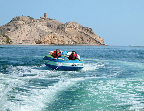
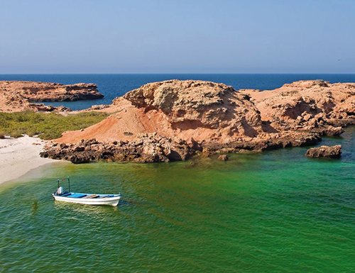
THE SAWADI BEACH & ISLANDS
Situated in Barka, the Sawadi Beach from afar looks as though a carpet of pink and white has been spread out on the shore, which on closer inspection turns out to be a blanket of thousands upon thousands of shells, that are home to tiny mollusks and button tops. With stunning golden sands and an uninterrupted view of the Sultanate’s pristine waters, escaping to the Sawadi beach is a perfect activity to unwind and relax. A short boat ride from the coast lie the Sawadi Beach Islands, a secluded island paradise where you can camp overnight under the millions of stars.
Carry all your provisions and gear when camping out on the Sawadi Beach Islands as there are no facilities available. Once you are ready to return to the shore, call for your boat to take you back.
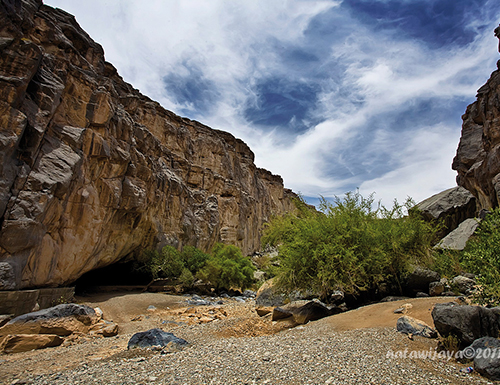
THE LITTLE & BIG SNAKE CANYONS
With spectacular views and taking its name from its shape, the Little Snake Canyon is the perfect place for tourists to explore in order to stretch their legs and enjoy the fresh air. Situated about 16 kilometers into Wadi Bani Auf, the Little Snake Canyon is accessible to all for the first few 100 meters. For the more adventurous and very experienced hikers, the Big Snake Canyon, close to the village of Al Zammah is a true challenge, with boulders to climb over and pools to swim through.
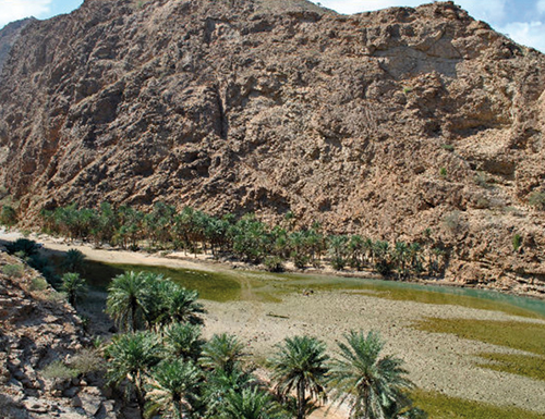
WADI BANI KHARUS
Probably one of the most well-known of all wadis in Oman, Wadi Bani Kharus lies at the town of Al Awabi, and is a journey into some 600 million yesteryears in geological time. Blessed with fascinating flora and fauna, the beautiful landscape casts a magical spell over visitors. The floor of the wadi is etched with rock art that predates the Islamic era, and further up the canyon walls are ancient fossils of snails and clams.
- Location : Al Awabi
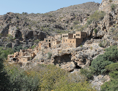
Check out the enchanting little village of Balad Sayt in Wadi Bani Auf which can be accessed through a short canyon on foot, or by a four wheel drive. While exploring the wadi, be ready to jump or swim at any given time, since some areas cannot be crossed otherwise.
WADI BANI AUF
Popularly known as ‘The Suspended Road’, lovers of adventure will find pleasure in the challenging mountain roads of Wadi Bani Auf that climb 2000 meters from the Batinah plain through the stunning Al Hajar Mountains to the base of Jebel Shams. Wires connect both ends of the wadi which the daring use to cross from one end to another. Spectacular views all around guarantee a never-ending photo session.
- Location : Between Rustaq & Al Awabi
The Governorate of A’Dakhiliyah
Occupying a distinctive location on the western end of the Al Hajar Mountains, and lying within the interior of Oman, the Governorate of A’Dakhiliyah has something for everyone; from extraordinarily high peaks and spectacular scenery, to some of the most ancient canals, grandiose forts and ruins of civilizations long gone. The wilayat of Nizwa in A’Dakhiliyah was famed for being the cradle of ardent intellectual activity and produced generations of Omani scientists, scholars and historians that have left behind relics of old houses and buildings that still stand today. Offering dramatic backdrops of the Sultanate’s highest mountain, Jebel Shams, and the famous green mountain, Jebel Akhdar, this region offers a palette to the tourist that is endless.
Main Cities Ad Dakhiliyah: Nizwa, Samail, Bahla, Adam, Al Hamra, Manah, Izki, Bidbid
JEBEL AKHDAR
With a temperature that is up to 20 degrees cooler than at land level, Jebel Akhdar rises as a grand spectacle of rocky slopes and sandy, barren ridges, which could cause some confusion in regard to its name, which means ‘Green Mountain’. Once the winding road finally stretches across the summit and the Saiq Plateau comes into view, Jebel Akhdar is a hidden paradise full of gardens, vegetation, and orchards that are secreted from view among the mazes of flowing wadis and terraces. The cool mountain air and high level of rainfall provides ideal conditions for cropping of all kinds of temperate fruit.
Only four wheel drives are permitted up the steep, twisting road of Jebel Akhdar. Make sure to carry a light sweater or shawl even during summer months, as the mountain gets chilly when dusk falls.
JEBEL SHAMS
Aptly named the ‘Mountain of the Sun’, Jebel Shams is Oman’s highest mountain, standing erect at an altitude of 3,004 meters above sea level, and renders a breathtaking vista at all times of the day. Each versant opens up to another versant, finally ending with the peak, close to which lies the infamous An’Nakhar Balcony, a deep ravine with chiseled formations that is best viewed from atop the rocks. Tourist guest houses have been built where tourists can spend time enjoying the serenity of this scenic mountain.
- Location : Jebel Shams
Drive through the Grand Canyon of Arabia through the An ‘Nakhar Balcony to witness spectacular displays of soaring mountain walls and imposing, rugged cliff edges.
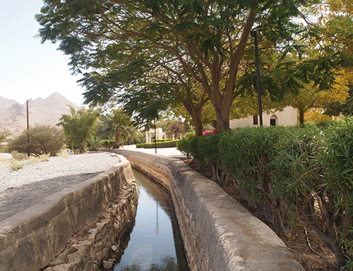
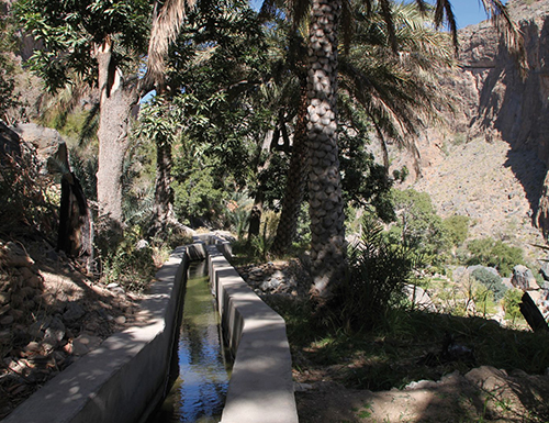
FALAJ DARIS
Falaj Daris is one of the largest irrigation canals in the Sultanate, and provides water for Nizwa and its surrounding areas since 500 AD. Located only a short drive away from Nizwa, this Falaj is a marvel of the ingenuity of Omani engineering. Set in a large park full of palm trees and shady spots, Falaj Daris is a great spot for a picnic and unwinding after a full day of sightseeing.
- Location : Nizwa, on the road to Bahla
The Governorate of A’Dhahirah
Descending from the southern slopes of the western end of the Al Hajar Mountains lies the Governorate of A’Dhahirah, which literally translates to ‘the back’. It forms a bridge between the trade routes of Oman and its neighbouring countries, which is why the region is called Ibri, meaning ‘crossing’. Much of the area is covered by an enormous, semi-sandy plain, and the arid desert conditions mean that A’Dhahirah is sparsely populated. However, this governorate contains relics of the Sultanate’s history that are a treasure not to be missed.
Main Cities of Al Dhahirah Governorate : Ibri, Yanqul, Dhanq
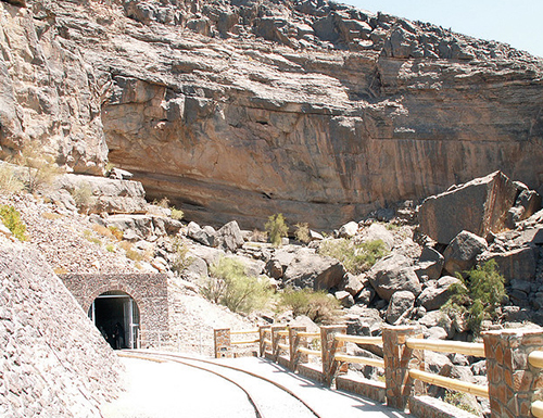
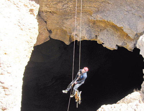
Al Hoota Cave
Having been discovered by the locale of A’Dakhiliyah hundreds of years ago, the Al Hoota Cave is a natural marvel that runs for about 5 kilometers, but can be accessed only up to a depth of 860 meters, ending at the Cave Lake, which is home to a rare species of blind fish. The Al Hoota Cave features a subterranean cavern filled with stalactites, stalagmites and colourful solid rock columns that can be explored through a train.
- Location : 30 minutes’ drive from Nizwa
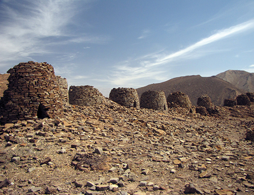
The Bat Tombs
Together with the neighbouring sites of Al Khutum and Al Ayn, Bat forms the archaeological site of the world’s most complete collection of settlements and necropolises from the 3rd millennium BC. Located to the east of Ibri, the Bat site was crowned a UNESCO World Heritage Site in 1988. Bat is a collection of graves that look very much like beehives. Consisting of 150 graves, tombs and other structures dotted across a rugged plain, the remains of the most complete tombs are from the Hafit and Umm An Nor period (3200 – 2000 BC).
- Location : Bat, ask for directions in the village
Wadi Damm
Located near the charming little village of Al Ayn, Wadi Damm is a seasonal wadi that remains dry for most part of the year, but transforms into a magical oasis during rainfall. It is remarkable for its characteristic rocky formations sculpted by erosion. The wadi is distinguished by a variety of smooth rocks, out of which nature has formed beautiful water ponds. One of the rocky formations sculpted by erosion is a small cave near the water pool, which is a fine camping site for tourists.
- Location : 45km from Ibri
Make sure to reach the wadi only by four wheel drive, as the rugged terrain will not support salon cars.
The Governorates of North & South A’Sharqiyah
Oman, being the myriad mix of natural wonders that it is, can proudly say that the Governorates of North and South A’Sharqiyah have a bit of everything that the Sultanate has to offer to the visitor and the locale alike. From the vast, golden deserts of the Wahiba Sands to the tranquil and serene beaches of Tiwi that extend right up to Sur and the island of Masirah, the imposing cliffs and awe-inspiring gorges of A’Sharqiyah meet the fertile wadis at the eastern extremities of the Al Hajar Mountains, down to the ancient towns of Sur, Ibra, and Sinaw, rendering an experience for the traveler that is truly unforgettable.
Ras Al Hadd Beach
Home to human settlements and trading activities since the 3rd millennium BC, the Ras Al Hadd beach lies 60 kilometers from Sur, the capital of the Governorate of South A’Sharqiyah. Fighter planes took shelter on its coast during the Second World War and the marks of the runways exist till today. Visitors can head towards the harbour and dip their legs down the scramble of rocks into the soothing sea water. Dhows anchored on the mudflats in the harbour, coupled with the receding sunlight in the evening creates a picture perfect panorama that is worth experiencing.
- Location : 60km from Sur
Never leave your children unattended on the rocks by themselves, as the crashing waves leave behind an assortment of sea life that can be slippery. It is advisable to not visit the shore during high tide.
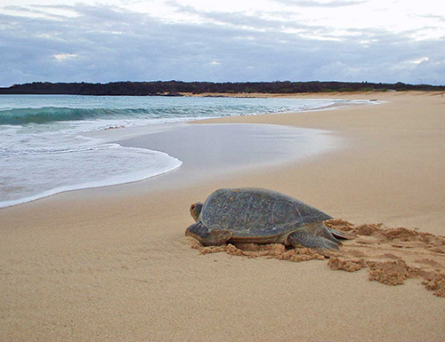
The Turtle Beach
Extending from Ras Al Hadd up to the island of Masirah lies the Ras Al Jinz Beach, more popularly referred to as The Turtle Beach, located right at the headland of the Arabian Peninsula. An average of 30,000 turtles visit the beach to nest annually, making Ras Al Jinz one of the largest nesting areas for Green Turtles in the Indian Ocean. Those staying up late or rising early may be lucky enough to see these magnificent creatures building their nests and laying eggs before heading back out to the sea. The area is protected by The Turtle Reserve and visits to the beach are strictly controlled.
- Location : Ras Al Jinz Turtle Reserve, Sur
Do not use flash photography while watching the turtles, as this inhibits them and stops them from nesting. You might want to use a faster lens or a higher ISO setting. Visiting hours are strictly limited, so book well in time to avoid disappointment.
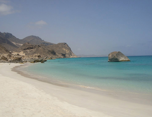
The White Beach
A stone’s throw away from the charming little town of Fins lies one of the most popular beaches between Muscat and Sur, known as The White Beach for its exquisite whitewashed sands. The beach is a spectacular place to camp overnight; during quieter times, it’s a perfect spot to stargaze and unwind to the gentle lapping of the milky waves.
- Location : 80km from Muscat/5km from Fins
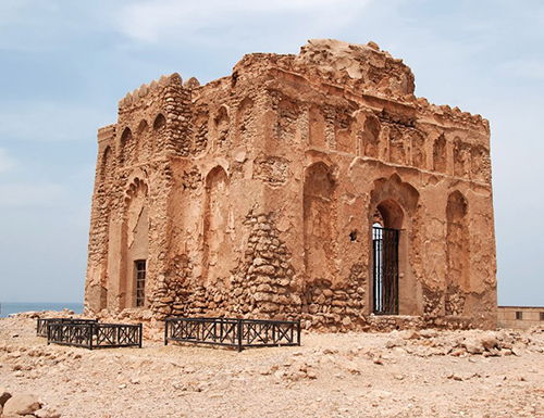
Bibi Miriam’s Tomb
Qalhat has been recorded in time as the site of a historic Omani civilization that settled here way before the advent of Islam. Once witness to prosperous times, Qalhat is now a pile of rocks, scattered over a wasteland of ruined houses, crumbling citadels, and walls that once fortified the city. It is said that the city fell prey to an earthquake in the fourteenth century, leaving behind the only standing remains of this thriving port: Bibi Miriam’s Tomb. Believed to have been built by Bahauddin Ayez, King of Hormuz, in the honour of his wife, the tomb is a crypt leading to underground corridors beneath the floor of the shrine.
- Location : Qalhat, on the road to Sur